Application Description
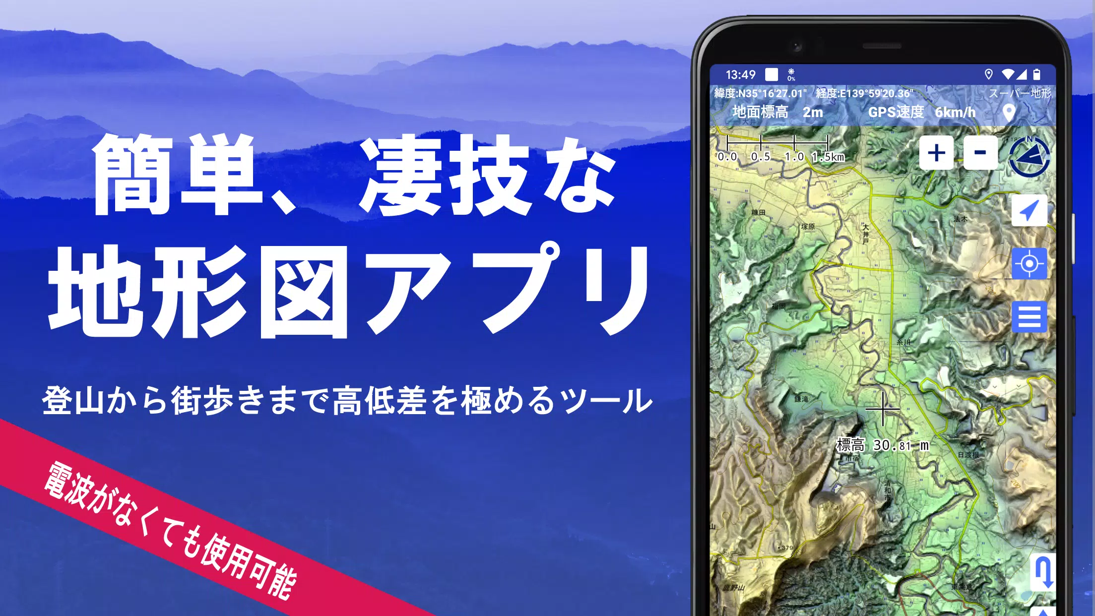
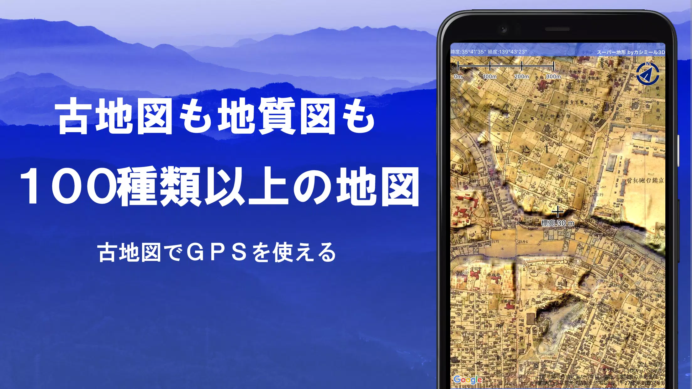
Explore over 100 types of maps, including the renowned Geographical Survey Institute map, which is perfect for everything from mountain climbing to leisurely strolls around town. This comprehensive mapping tool received the prestigious 2018 Japan Cartographic Society Award for Best Work, underscoring its utility and innovation in the field of cartography.
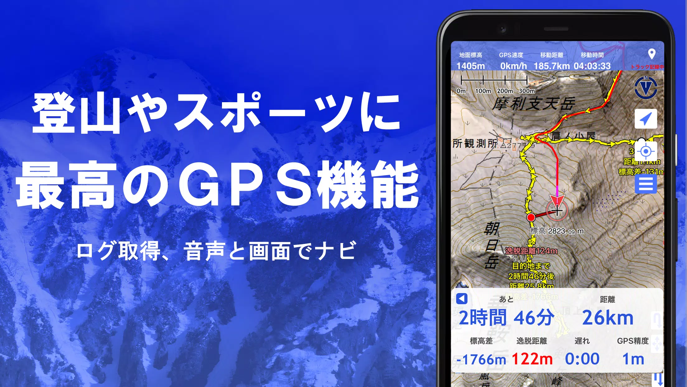
The app utilizes "super terrain data" to enhance terrain visualization using unique technology. Users can access an array of maps from the Geospatial Information Authority of Japan, including topographic, geological, historical, and prewar maps. The GPS functionality allows you to record tracks (trajectories), with options for GPX log input/output and editing. This makes it an ideal companion for urban exploration, mountain climbing, and other outdoor activities, complete with GPS navigation featuring audio support, data recording, and editing capabilities.
Enhance your experience with the visibility determination function, useful for creating cross-sectional diagrams and aiding in observation and radio communication. Buildings can also be visualized, adding a layer of detail to your maps. The 360° panoramic view function aids in mountain identification, displaying not only the names of mountains but also the positions of the sun, moon, and GPS points. Enjoy seamless offline use with GPS functionality, bulk map downloads, and map caching, ensuring a lag-free experience even in areas without a signal.
Additional features include the ability to associate photos with specific points, display contour lines generated from elevation data, and show MGRS grids (UTM grids). The app supports reading, displaying, and editing GIS data from GeoJSON files, as well as drawing shapes. It's versatile enough for use overseas, supports map printing and PDF output, and offers a dark theme for user convenience.
1. A Wealth of Maps That Can Be Used
The app boasts over 100 usable maps, including our proprietary super topographic data and maps from the Geospatial Information Authority of Japan. Note that aerial photographs may not be available in all locations, with the "Latest" and "around 1974" categories offering relatively wide coverage. Maps utilizing super terrain data are free to use for the first 5 days after installing the app.
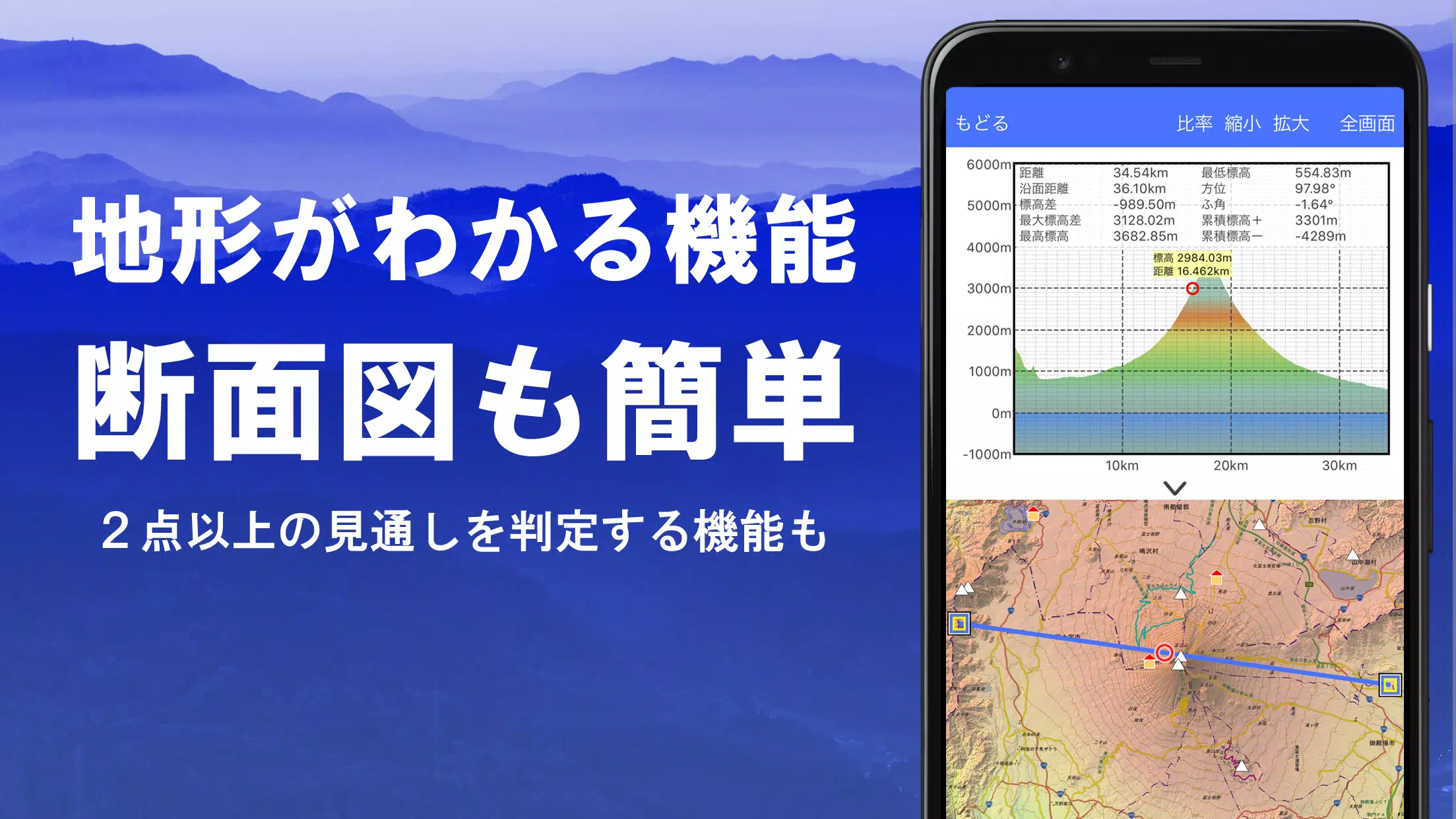
2. Creation of Cross Sections and Outlooks
Easily draw cross-sections through any point on the map. The app includes a visibility judgment function from Kashmir 3D, which accounts for the Earth's curvature and atmospheric differences. This is invaluable for route planning during climbs, assessing wireless visibility, and understanding terrain. Where PLATEAU building data is available, you can create cross-sectional views that include buildings.
3. Elevation Palette Function
Utilize the elevation palette function to customize the map background with your favorite colors, adjusting in 1cm increments for a personalized experience.
4. Panoramic View
The panoramic observation map displays mountain names from any point on the map, offering a 360° view that syncs with your smartphone's compass for accurate mountain identification. You can also view the sun and moon, including moon phases, which is perfect for exploring phenomena like Diamond Fuji and Pearl Fuji. The app supports viewing GPS points and drawing panoramic views of mountains worldwide.
5. GPS Function
Leverage your smartphone's GPS to obtain location data and record tracks. The app's high-precision positioning is ideal for serious mountain climbing and outdoor use. Tracks can be graphically displayed with parameters such as elevation, speed, time, and elapsed time. A point alarm function notifies you via voice or alarm when approaching a specific point, and you can view photos associated with these points. The app also allows you to send the map center position to NaviCon.
6. GPS Track Summary Playback
Replay your recorded tracks comprehensively, with the app automatically matching and displaying photos based on their capture times. An icon marks the photo's location, which you can view by tapping.
7. GPS Navigation Function
Navigate along preset tracks using the Track Navi feature, with voice or alarm alerts if you deviate from the path. This ensures you won't get lost during your climbs. The app also supports route navigation for urban walks and point navigation to reach specific locations.
8. GPS Data Editing Function
Manage GPS-related point, route, and track data organized in folders and displayed in a user-friendly tree format. Create tracks directly on the map, and import or export them in GPX format from various mountain climbing sites.
9. Map Usage Outside the Service Area (Offline)
Use maps even in remote areas without a signal, thanks to the bulk download feature, which allows you to download all scale maps for a specified area. A cache function further enhances offline usability, ensuring you always have access to necessary maps.
10. Map History Function
The app remembers previously viewed locations, enabling you to return to them easily.
11. Custom Map Compatibility
Import and use custom maps cut with Kashmir 3D's map cutter, displaying your own maps or scanned maps. When using the map cutter, divide each image into approximately 256 x 256 sections and send the resulting kmz file to Super Terrain via email or cloud drive.
12. GeoJSON Compatibility
Display and edit points, linestrings, and polygons from GeoJSON format files, with the ability to draw new shapes.
13. Print/PDF Output
Print any map area at a specified scale or generate a PDF for further use.
14. Cooperation with Other Apps
Input and output GPS data in GPX, KML, and GDB formats, facilitating data exchange with other apps, Kashmir 3D on your PC, and trajectory data from mountain climbing sites.
15. Backup Function
Back up all data within the app (excluding cached maps) and remove it from your smartphone for safekeeping. You can restore the data even if you delete the app or experience a device malfunction. An automatic backup feature using Google Drive ensures your data remains up-to-date. For detailed information, refer to the manual.
16. About Billing Function
Some features, including maps using super terrain data, GPS track functions, and cross-sectional views, are available via in-app purchases. After payment, the number of search results for place name searches increases.
- Fees: Annual payment of 780 yen/year.
- Free Trial: Enjoy a 5-day free trial upon first installation. After 5 days, some features and maps will be unavailable unless you purchase them. Charges only apply if you choose to buy within the app.
- Confirmation and Cancellation: Check or cancel automatic updates through Google Play under "Regular Purchase" and select "Super Terrain."
- Price Revision: Future feature enhancements may lead to price revisions. Early purchase is recommended for the best value.
17. Terms of Use
The copyright holder and developer are not responsible for the outcomes of using this application. Upon first use of GPS, you'll be prompted to allow location services. Continuous GPS use can drain your battery, so if your device is needed for emergency communication, carry a spare battery. For a detailed explanation of the navigation function, refer to the PDF at https://www.kashmir3d.com/online/superdemapp/superdem_navi.pdf. Note that some smartphones may interrupt or fail to record tracks due to power-saving features, which cannot be resolved by the app.
Screenshot
Reviews
Post Comments
Latest Articles

Final Fantasy IX Remake Rumors Intensify With Anniversary Leaks
Final Fantasy IX has unveiled its 25th-anniversary website, detailing a series of upcoming projects. Discover more about the plans for this milestone celebration and potential future developments.Final Fantasy IX Marks 25th Anniversary This Year25th

Sonic Rumble Battle Royale Launches Globally Next Month
Sonic Rumble, the highly anticipated battle royale game, will launch next month.You can download it on iOS and Android starting May 8th.Pre-registration bonuses remain available for a limited time.Following Sega's acquisition of Rovio a few years bac

Demon Slayer: Hinokami Chronicles 2 Launch Revealed
Is Demon Slayer The Hinokami Chronicles 2 Coming to Xbox Game Pass?Currently, Demon Slayer The Hinokami Chronicles 2 has not been confirmed for inclusion in Xbox Game Pass. Fans eagerly awaiting its potential arrival on the subscription service will

Resident Evil announces collab with heavy metal idol group BABYMETAL
Resident Evil is teaming up with the chart-topping metal idol group BABYMETAL.
The collaboration will feature exclusive merchandise and more, launching in 2026.
This partnership marks the celebration of 30 years of Resident Evil, including the upcomi
The Bazaar Pre-Orders Include Exclusive DLC
Discover everything you need to rise to the top within the vibrant and bustling stalls of The Bazaar. Learn how to pre-order, pricing details, and whether alternate editions and DLC are available.← Return to The Bazaar main articleThe Bazaar Pre-Orde

Pokémon Reality Show Focuses on TCG Action
Pokémon is spotlighting its passionate fanbase with an exciting new reality series! Discover everything about this innovative show and where to watch it.Catch Pokémon: Trainer Tour TodayA Celebration of the Pokémon TCG and its CommunityPokémon enthus
Apps like スーパー地形 - GPS対応地形図アプリ

台北捷運Go
Maps & Navigation丨96.5 MB


Trafi
Maps & Navigation丨23.6 MB
Crawfisher LE
Maps & Navigation丨33.1 MB

Kigo - Parkimovil
Maps & Navigation丨42.8 MB

SALAM TAXI KZ
Maps & Navigation丨12.1 MB

BP Fatár
Maps & Navigation丨3.6 MB
Latest Apps

Salute, Jazz
Productivity丨56.40M


Barbearia 903
Beauty丨78.1 MB

GoBiz - GoFood Merchant App
Business丨65.8 MB


Vivaldi Browser Snapshot
Communication丨264.2 MB

Hippie Dating
Dating丨27.1 MB

EveryCircuit
Education丨10.4 MB
Trending Apps
MORE +


Top News
MORE +


01
03-28
Top Streaming Platforms for Live Sports in 2025
Gone are the days when watching sports was as simple as turning on your TV and tuning into the big game. Today, the landscape of sports streaming has become a complex web of regional blackouts, paywalls, and exclusive rights that can leave fans feeling lost. With numerous streaming services vying fo
02
12-25
Vienna Opera Delight: Reverse 1.99 Update
Reverse: 1999 Version 1.7 Update: A Viennese Adventure Awaits!
Bluepoch Games' Reverse: 1999 is taking players on a trip back in time with its latest update, Version 1.7, launching players into the captivating world of early 20th-century Vienna in the new "E Lucevan Le Stelle" event. This update del
03
01-23
“Descenders” Codes Unlock January 2025 Content
Descenders: A Thrilling Bike Racing Game with Active Codes!
Descenders delivers exhilarating bike racing action and boasts impressive reviews. Explore diverse locations, perform daring stunts, and choose from a wide variety of bikes and gear. Realistic bike physics make riding and pulling off tric
04
11-13
Black Myth: Wukong Review Impresses Amid Guideline Debate
After four long years of waiting since its first announcement in 2020, the verdict is in for Black Myth: Wukong! Read more to learn more about the details and what other reviewers thought about the game.Black Myth: Wukong Is Almost HereBut Only On PCEver since its first trailer back in 2020, Black M
05
02-02
Roblox Grace Commands Guide Released
Grace Roblox Game Commands: A Comprehensive Guide
Grace is a challenging Roblox experience featuring terrifying entities and demanding levels. To aid players, especially during testing, a set of in-game commands is available on test servers. This guide details all commands and their usage.
All Grac