Application Description
Offline maps, GPS navigation, real-time traffic updates, parking assistance, transit routes, and more
2GIS offers comprehensive maps with GPS navigation for drivers and pedestrians, featuring live traffic data, public transport schedules, and an extensive city directory. Access maps online or download them for offline use to navigate seamlessly without an internet connection.
With 2GIS maps and navigation, you'll confidently explore unfamiliar locations:
— Quickly locate addresses, businesses, contact details, operating hours, and available products or services;
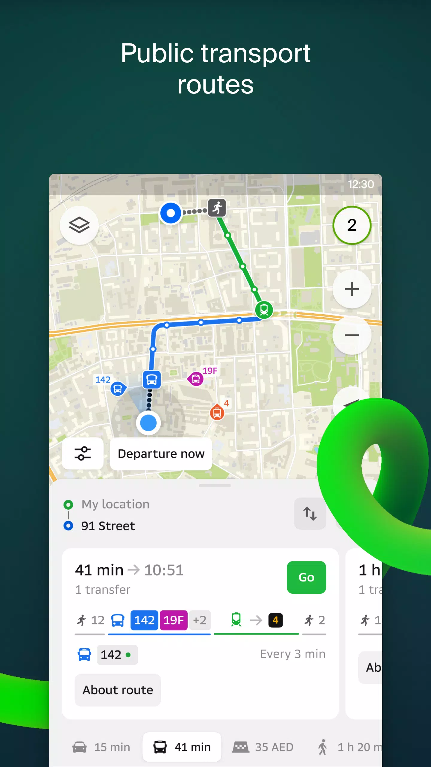
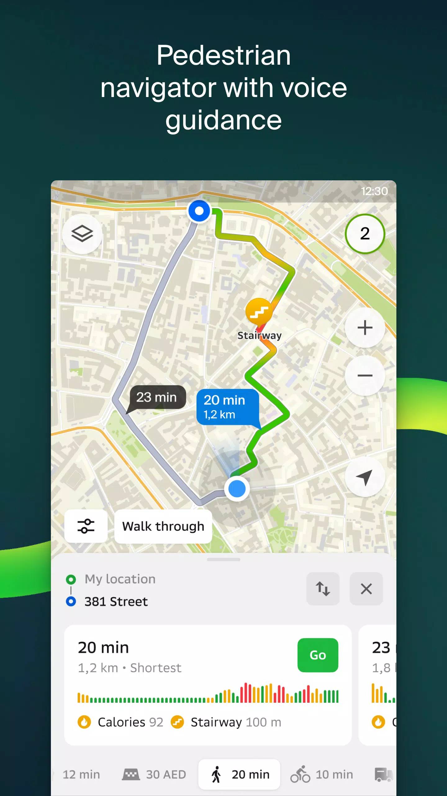
— Get precise directions for driving, public transport, or walking with turn-by-turn navigation;
— Easily find building entrances and nearby parking spots.
Highly detailed maps. Locate neighborhoods, buildings, roads, transit stops, subway stations, fueling stations, sports facilities, and other points of interest.
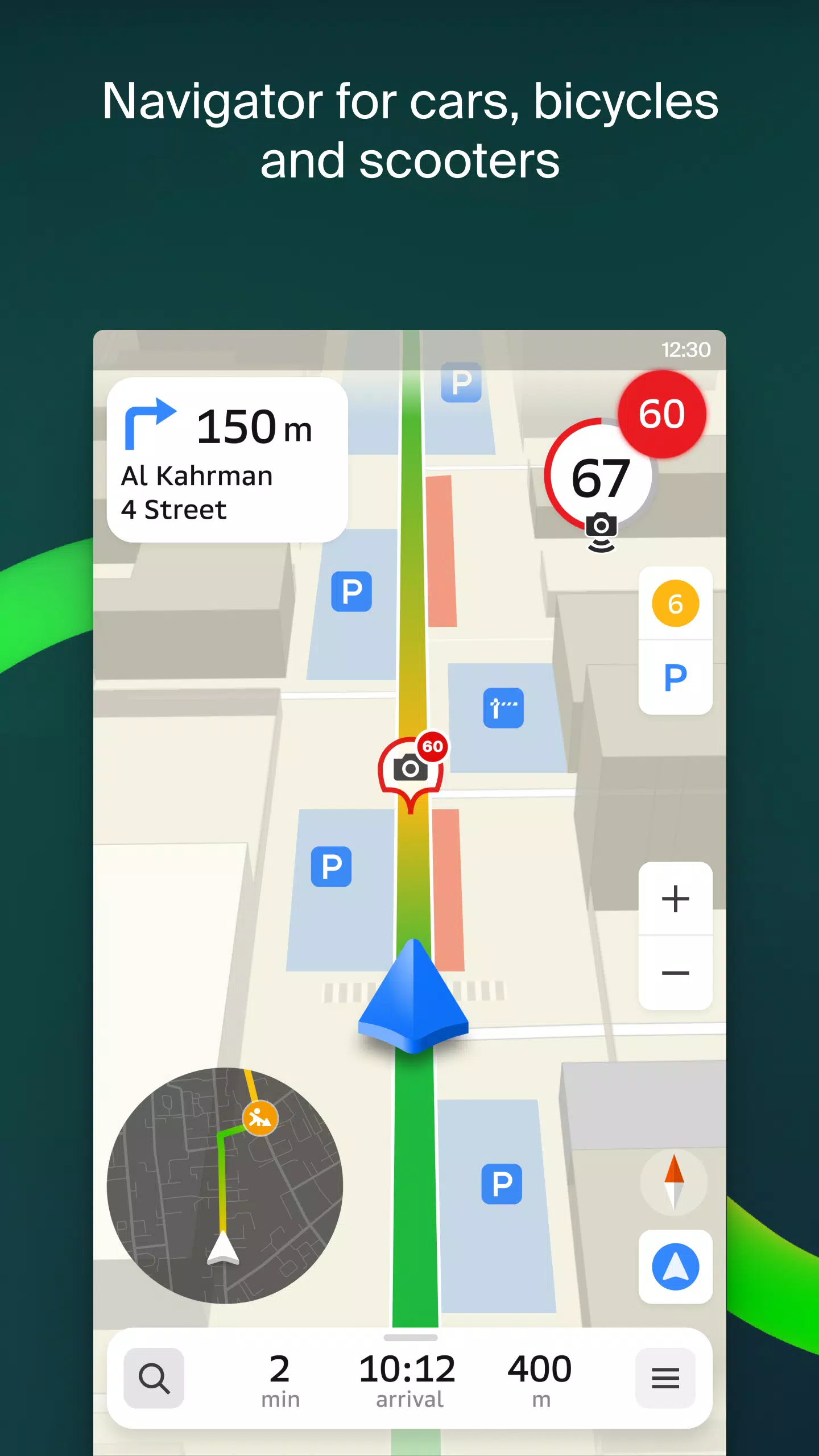
Advanced GPS navigation. Accounts for live traffic conditions, road signs, speed cameras, toll roads, and unpaved routes while planning multi-city trips with waypoints. Compatible with Android Auto.
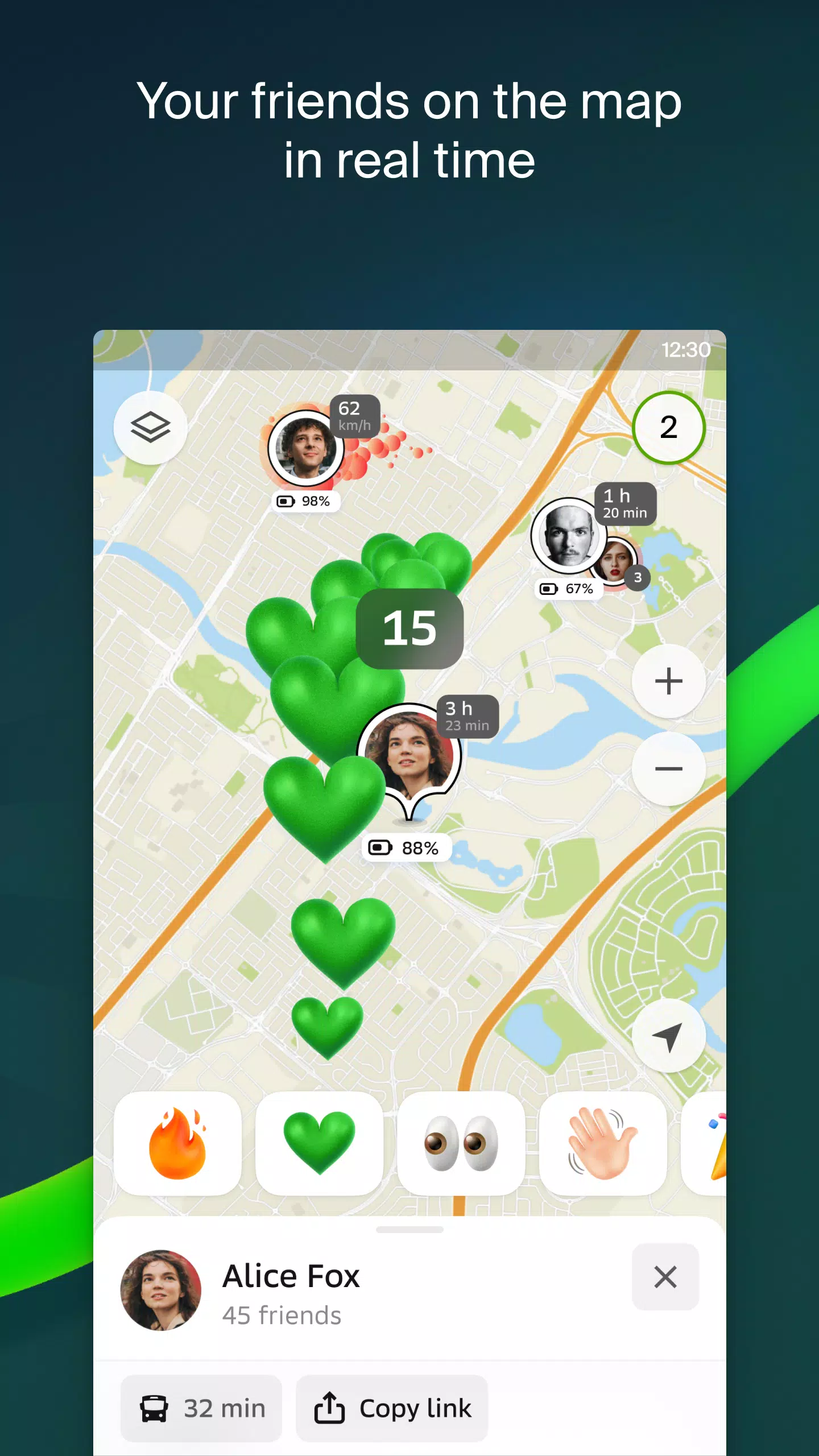
Real-time friend tracking. Monitor family members or friends' locations for safety using GPS tracking. Exchange stickers and view battery status. Full control over friend lists and location sharing permissions.
Road incident reports. Stay informed about accidents, road closures, speed cameras, and community-reported issues directly on your map.
Public transport information. Access accurate timetables and optimized transit route planning.
Pedestrian navigation. Detailed walking directions with voice guidance and background operation.
Commercial vehicle routing. Specialized navigation for trucks considering vehicle specifications and cargo requirements.
Comprehensive business directory. Features addresses, building access points, postal codes, contact information, social media links, website URLs, and entrance locations. Includes user-submitted photos and reviews.
Travel guide functionality. Discover key attractions, free Wi-Fi spots, and other useful locations.
Wear OS companion app. Seamlessly extends your navigation experience to Wear OS 3.0+ smartwatches, providing map views, maneuver alerts, and vibration notifications for turns or transit stops. Automatically syncs with your phone's navigation.
Available map coverage:
UAE Cities:
Dubai, Sharjah, Abu Dhabi, Al Ain, Ajman, Ras Al Khaimah, Fujairah, Umm Al Quwain, Dibba Al Fujairah, Khor Fakkan, Kalba, Al Salamh, etc.
Russian Cities:
Moscow, Saint Petersburg, Novosibirsk, Yekaterinburg, Krasnoyarsk, Chelyabinsk, Ufa, Omsk, Kazan, Perm, Nizhny Novgorod, Sheregesh, etc.
Cities in Belarus, Kazakhstan, Uzbekistan, Azerbaijan and Kyrgyzstan:
Minsk, Pavlodar, Semey, Aktau, Aktobe, Almaty, Nur-Sultan, Bishkek, Karaganda, Kokshetau, Kostanay, Osh, Baku, Tashkent, etc.
Support contact: [email protected]
Screenshot
Reviews
Post Comments
Latest Articles
Sonic Rumble Battle Royale Launches Globally Next Month
Sonic Rumble, the highly anticipated battle royale game, will launch next month.You can download it on iOS and Android starting May 8th.Pre-registration bonuses remain available for a limited time.Following Sega's acquisition of Rovio a few years bac

Demon Slayer: Hinokami Chronicles 2 Launch Revealed
Is Demon Slayer The Hinokami Chronicles 2 Coming to Xbox Game Pass?Currently, Demon Slayer The Hinokami Chronicles 2 has not been confirmed for inclusion in Xbox Game Pass. Fans eagerly awaiting its potential arrival on the subscription service will

Resident Evil announces collab with heavy metal idol group BABYMETAL
Resident Evil is teaming up with the chart-topping metal idol group BABYMETAL.
The collaboration will feature exclusive merchandise and more, launching in 2026.
This partnership marks the celebration of 30 years of Resident Evil, including the upcomi
The Bazaar Pre-Orders Include Exclusive DLC
Discover everything you need to rise to the top within the vibrant and bustling stalls of The Bazaar. Learn how to pre-order, pricing details, and whether alternate editions and DLC are available.← Return to The Bazaar main articleThe Bazaar Pre-Orde

Pokémon Reality Show Focuses on TCG Action
Pokémon is spotlighting its passionate fanbase with an exciting new reality series! Discover everything about this innovative show and where to watch it.Catch Pokémon: Trainer Tour TodayA Celebration of the Pokémon TCG and its CommunityPokémon enthus
Star Dive to Showcase at Gamescom 2025
Mongil: Star Dive will feature a prominent hands-on demo station at Gamescom 2025Attendees can experience the game on both mobile and desktop platforms, including a new 3D gaming monitorA nearby event will offer additional hands-on opportunities and
Apps like 2GIS: Offline map & navigation


Trafi
Maps & Navigation丨23.6 MB
Crawfisher LE
Maps & Navigation丨33.1 MB

Kigo - Parkimovil
Maps & Navigation丨42.8 MB


SALAM TAXI KZ
Maps & Navigation丨12.1 MB

BP Fatár
Maps & Navigation丨3.6 MB
Latest Apps
Draw The Flag
Art & Design丨15.9 MB

Imaginator
Art & Design丨58.8 MB

1SStory
Art & Design丨61.6 MB


Anime Pixel
Art & Design丨13.9 MB


Trending Apps
MORE +


Top News
MORE +
01
03-28
Top Streaming Platforms for Live Sports in 2025
Gone are the days when watching sports was as simple as turning on your TV and tuning into the big game. Today, the landscape of sports streaming has become a complex web of regional blackouts, paywalls, and exclusive rights that can leave fans feeling lost. With numerous streaming services vying fo
02
12-25
Vienna Opera Delight: Reverse 1.99 Update
Reverse: 1999 Version 1.7 Update: A Viennese Adventure Awaits!
Bluepoch Games' Reverse: 1999 is taking players on a trip back in time with its latest update, Version 1.7, launching players into the captivating world of early 20th-century Vienna in the new "E Lucevan Le Stelle" event. This update del
03
11-13
Black Myth: Wukong Review Impresses Amid Guideline Debate
After four long years of waiting since its first announcement in 2020, the verdict is in for Black Myth: Wukong! Read more to learn more about the details and what other reviewers thought about the game.Black Myth: Wukong Is Almost HereBut Only On PCEver since its first trailer back in 2020, Black M
04
01-23
“Descenders” Codes Unlock January 2025 Content
Descenders: A Thrilling Bike Racing Game with Active Codes!
Descenders delivers exhilarating bike racing action and boasts impressive reviews. Explore diverse locations, perform daring stunts, and choose from a wide variety of bikes and gear. Realistic bike physics make riding and pulling off tric
05
02-02
Roblox Grace Commands Guide Released
Grace Roblox Game Commands: A Comprehensive Guide
Grace is a challenging Roblox experience featuring terrifying entities and demanding levels. To aid players, especially during testing, a set of in-game commands is available on test servers. This guide details all commands and their usage.
All Grac